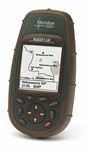
 I’ve recently been doing some research on current GPS devices since I broke my own about year ago. I used to use a Magellan Meridian which I’ve been extremely satisfied with. Still, it’s probably not worth a repair intent as it’s the display that is damaged. Besides, the map material available for the device is of course totally outdated as is the hardware itself. So I currently looking for a new device.
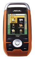 Long story short, I’ve never been to fond of the Garmin devices and as I’m looking for an outdoor GPS for hiking, mountain biking, etc., I found the Magellan Triton series to be particularly interesting. Color touch screen, rugged, nice interface, support for Geo Caching and depending on the model flashlight, camera and many more features make this device really interesting. BUT it has one very large drawback! Magellan doesn’t seem to interested in Europe too much, meaning, there’s only country boundaries and large streets on the device’s integrated base map and no detailed maps available to buy and / or download (besides some special maps like waterways and topographic maps for Norway). Since I’m planning to use this thing mainly in Europe that would be an absolute no-buy reason.
 Fortunately a little digging brought up that there’s plenty of 3rd party maps and tools available for the Magellan Triton. Seems that the device’s map format is publicly known. I don’t know whether it’s been made available by Magellan or just been figured out by someone but this fact allows to create proper maps for the device. Plenty of such maps for various countries all over the world are linked on http://www.maps4me.de/ and a few more links plus a lot of user support info can be found at http://www.magellanboard.de. There’s one map I’d especially like to point out: A topographic map of Germany for the Magellan Triton created using the OpenStreetMap data as a basis. I find it just awesome that this way you get a full topographic map for Germany which may not be perfectly complete but in some cases even more detailed than commercial maps for free. Beside that I just like the idea behind OpenStreetMap as I pointed out in an earlier post, I’m also quite fond of the fact that using OSM on your GPS device, you can kill two birds with one stone. First you get a free map for your device and then, wherever you find spots, tracks or streets missing in this map, you can just hit the “record button” on your receiver and using your PC, add the recorded data to OpenStreetMap on their site.
After all, the availability of an OSM map for the Magellan Triton might be the one decisive reason, to finally convince me, that this should be might next GPS device.
looking forward for more information about this. thanks for sharing. Eugene
Well??? Did you buy it? Did you use it? How did it work for you?
I’m looking at a Triton 500 right now and I already have a lot streets and paths in mind that I want to add to OSM. There is a dearth of reviews on Magellan and OSM though.
Yes, I do actually have one of these. But I must admit I’m not completely sold!
It works well and does the job, yet I’m a bit disappointed on the screen which does a really bad job in sunlight and the software which isn’t too well thought through and also responds a bit slow. The form factor of the devices probably isn’t the best choice either (being a bit too broad).
All in all if feels a little bit cheap, like being an extremely stripped down, cheap version of Magellan’s MobileMapper (which it probably is). Again: It’s OK and it does the job but you can clearly see that Magellan didn’t put too much effort into this device which is a bit sad considering its price point. If I were buying another device with similar price and functionality, I’d definitely have a much closer look at the Garmin Oregon series.