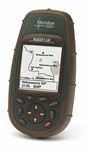
 I’ve recently been doing some research on current GPS devices since I broke my own about year ago. I used to use a Magellan Meridian which I’ve been extremely satisfied with. Still, it’s probably not worth a repair intent as it’s the display that is damaged. Besides, the map material available for the device is of course totally outdated as is the hardware itself. So I currently looking for a new device.
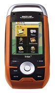 Long story short, I’ve never been to fond of the Garmin devices and as I’m looking for an outdoor GPS for hiking, mountain biking, etc., I found the Magellan Triton series to be particularly interesting. Color touch screen, rugged, nice interface, support for Geo Caching and depending on the model flashlight, camera and many more features make this device really interesting. BUT it has one very large drawback! Magellan doesn’t seem to interested in Europe too much, meaning, there’s only country boundaries and large streets on the device’s integrated base map and no detailed maps available to buy and / or download (besides some special maps like waterways and topographic maps for Norway). Since I’m planning to use this thing mainly in Europe that would be an absolute no-buy reason. Continue Reading